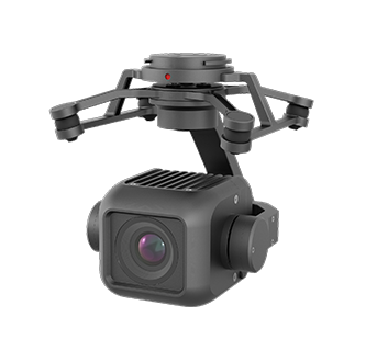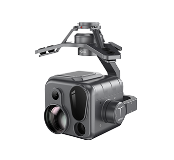

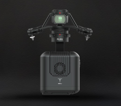
PLI01 is a lightweight LiDAR developed for multi-rotors. It's built with a compact LiDAR system, an inertial navigation system, a control system, and high-resolution mapping cameras for S400E.
Key Features
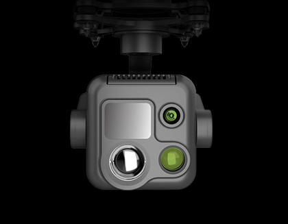
Lightweight & Compact Design
Optimized for Multi-Rotors: Compact build integrates LiDAR, inertial navigation, control system, and mapping cameras
Portable Efficiency: Designed for easy mounting while minimizing drone payload strain
Versatile Application Range: Supports surveying, forestry, agriculture, power, and safety missions
High-Performance Data Capture
Triple Echo Capability: Captures and processes up to 720,000 points per second, penetrating vegetation for hidden details
Extended Range: Measures distances up to 450 m (at 80% reflectivity) for wide-area surveys
Coverage: Maps areas up to 2 km² (494.2 acres) in a single flight
Precision & Accuracy
Centimeter-Level Point Clouds: Powered by GNSS and high-precision IMU for survey-grade outputs
Detail-Rich Representation: Ideal for urban planning, land management, and environmental analysis
Risk Detection: Identifies unstable terrain, vegetation encroachment, and other hazards
Seamless Workflow
One-Click Software Suite: Enables automatic point cloud processing and defect detection
Smart Flight Planning: Integrated tools for route optimization and efficient data collection
Data Integration: Compatible with common geospatial workflows and platforms
Why Choose This Kit?
The PLI01 LiDAR combines lightweight portability, triple echo technology, and centimeter-level accuracy to deliver high-quality point clouds at scale Its long range, large coverage area, and automated software suite make it an efficient and reliable tool for mapping, inspection, and environmental monitoring
Ideal For
Surveying and mapping professionals, forestry and agricultural monitoring teams, utility companies inspecting power lines, and disaster response units requiring precise terrain and vegetation analysis
PLI01 is a lightweight LiDAR developed for multi-rotors. It's built with a compact LiDAR system, an inertial navigation system, a control system, and high-resolution mapping cameras for S400E.
Key Features
Lightweight & Compact Design
Optimized for Multi-Rotors: Compact build integrates LiDAR, inertial navigation, control system, and mapping cameras
Portable Efficiency: Designed for easy mounting while minimizing drone payload strain
Versatile Application Range: Supports surveying, forestry, agriculture, power, and safety missions
High-Performance Data Capture
Triple Echo Capability: Captures and processes up to 720,000 points per second, penetrating vegetation for hidden details
Extended Range: Measures distances up to 450 m (at 80% reflectivity) for wide-area surveys
Coverage: Maps areas up to 2 km² (494.2 acres) in a single flight
Precision & Accuracy
Centimeter-Level Point Clouds: Powered by GNSS and high-precision IMU for survey-grade outputs
Detail-Rich Representation: Ideal for urban planning, land management, and environmental analysis
Risk Detection: Identifies unstable terrain, vegetation encroachment, and other hazards
Seamless Workflow
One-Click Software Suite: Enables automatic point cloud processing and defect detection
Smart Flight Planning: Integrated tools for route optimization and efficient data collection
Data Integration: Compatible with common geospatial workflows and platforms
Why Choose This Kit?
The PLI01 LiDAR combines lightweight portability, triple echo technology, and centimeter-level accuracy to deliver high-quality point clouds at scale Its long range, large coverage area, and automated software suite make it an efficient and reliable tool for mapping, inspection, and environmental monitoring
Ideal For
Surveying and mapping professionals, forestry and agricultural monitoring teams, utility companies inspecting power lines, and disaster response units requiring precise terrain and vegetation analysis

- •1× GDU PLI01 LiDAR