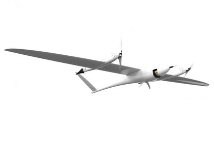


Quantum Systems Trinity Pro e-VTOL Fixed-Wing Mapping Drone
- Order within
The Trinity F90+ demonstrates its range advantage in comparison to classic multicopters and other fixed-wing drones due to the longer flight time and covers up to 20x larger areas. The larger the area to be covered, the more attractive the use of the Trinity F90+ will be.
- 90+ min flight time in combination with the widest range of payload options available
- PPK including Quantum-System iBase Ground Reference Station powered by u-blox
- RGB & multispectral (dual) payload options
- Powerful motors for even more reserves in all situations
- Live Air Traffic (ADS-B) & QBase Mission Planning
- 2.4 GHz telemetry with up to 7.5 km range
- Optional ADS-B Mode-S out
More survey data in less time a win-win situation
Whether in the agricultural sector, in the mining business or when inspecting industrial plants and construction progress, more data can be recorded in a very short time than it was previously possible with conventional systems.
The Trinity F90+ demonstrates its range advantage in comparison to classic multicopters and other fixed-wing drones due to the longer flight time and covers up to 20x larger areas. The larger the area to be covered, the more attractive the use of the Trinity F90+ will be.
QBase3D – Intuitive Misson Planning
The mission planning software is the main interface between the user and the drone. QBase3D provides simple and intuitive planning in combination with advanced functionality for professional users.
Using QBase 3D is the way to pre-plan an aerial survey mission for Quantum-Systems UAVs.
QBase 3D automatically generates efficient flight paths after the flight area and the mission parameters have been defined with a few clicks. You are in complete control over your photogrammetric aerial survey mission and and full coverage of your area of interest is guaranteed.
QBase 3D provides real-time information such as altitude, speed, heading and battery status about the UAV and telemetry data about the mission that helps the pilot to stay up to date all the times.
3D planning for more safety
With integrated 3D view we offer an efficient tool to plan even more precisely and to keep a perfect overview during the flight. Intuitive and practical.
One Software - Many Application Scenarios
Quantum-System UAVs combined with QBase 3D help surveyors, farmers, scientists, quarrymen, civil engineers and geologists to focus on their application, allowing them to just fly!
Stay up to date
QBase 3D is a constantly evolving product. Continous system updates for all Quantum-Systems UAVs as well as Qbase 3D itself guarantee maximum future security. During operation, live weather data support mission planning.
Simple and fast
Thanks to QBase 3D all mission relevant steps from planning to flying can be carried out intuitively.
PPK capability in every situation
PPK and RTK (post-processing kinematics and real-time kinematics) are the algorithms that allow the user to cancel most of GNSS errors via processing data from two receivers that are close enough to each other.
They share the same common errors for most error sources such as ionospheric and tropospheric influence on the signal transmission, satellites ephemeris and clock errors.
As it is clear from the names, RTK is performed in real time, PPK – in post-processing.
When properly applied, these algorithms reduce positioning errors from several meters (typical for standalone GNSS receivers) down to centimeters.
iBase is an entry level GNSS reference station. It automatically logs GNSS reference measurements on the ground to a file on a micro SD card. This file enables QBase3D to do PPK processing of the collected survey data with a absolute accuracy of 2 – 5 cm.
The Trinity F90+ demonstrates its range advantage in comparison to classic multicopters and other fixed-wing drones due to the longer flight time and covers up to 20x larger areas. The larger the area to be covered, the more attractive the use of the Trinity F90+ will be.
- 90+ min flight time in combination with the widest range of payload options available
- PPK including Quantum-System iBase Ground Reference Station powered by u-blox
- RGB & multispectral (dual) payload options
- Powerful motors for even more reserves in all situations
- Live Air Traffic (ADS-B) & QBase Mission Planning
- 2.4 GHz telemetry with up to 7.5 km range
- Optional ADS-B Mode-S out
More survey data in less time a win-win situation
Whether in the agricultural sector, in the mining business or when inspecting industrial plants and construction progress, more data can be recorded in a very short time than it was previously possible with conventional systems.
The Trinity F90+ demonstrates its range advantage in comparison to classic multicopters and other fixed-wing drones due to the longer flight time and covers up to 20x larger areas. The larger the area to be covered, the more attractive the use of the Trinity F90+ will be.
QBase3D – Intuitive Misson Planning
The mission planning software is the main interface between the user and the drone. QBase3D provides simple and intuitive planning in combination with advanced functionality for professional users.
Using QBase 3D is the way to pre-plan an aerial survey mission for Quantum-Systems UAVs.
QBase 3D automatically generates efficient flight paths after the flight area and the mission parameters have been defined with a few clicks. You are in complete control over your photogrammetric aerial survey mission and and full coverage of your area of interest is guaranteed.
QBase 3D provides real-time information such as altitude, speed, heading and battery status about the UAV and telemetry data about the mission that helps the pilot to stay up to date all the times.
3D planning for more safety
With integrated 3D view we offer an efficient tool to plan even more precisely and to keep a perfect overview during the flight. Intuitive and practical.
One Software - Many Application Scenarios
Quantum-System UAVs combined with QBase 3D help surveyors, farmers, scientists, quarrymen, civil engineers and geologists to focus on their application, allowing them to just fly!
Stay up to date
QBase 3D is a constantly evolving product. Continous system updates for all Quantum-Systems UAVs as well as Qbase 3D itself guarantee maximum future security. During operation, live weather data support mission planning.
Simple and fast
Thanks to QBase 3D all mission relevant steps from planning to flying can be carried out intuitively.
PPK capability in every situation
PPK and RTK (post-processing kinematics and real-time kinematics) are the algorithms that allow the user to cancel most of GNSS errors via processing data from two receivers that are close enough to each other.
They share the same common errors for most error sources such as ionospheric and tropospheric influence on the signal transmission, satellites ephemeris and clock errors.
As it is clear from the names, RTK is performed in real time, PPK – in post-processing.
When properly applied, these algorithms reduce positioning errors from several meters (typical for standalone GNSS receivers) down to centimeters.
iBase is an entry level GNSS reference station. It automatically logs GNSS reference measurements on the ground to a file on a micro SD card. This file enables QBase3D to do PPK processing of the collected survey data with a absolute accuracy of 2 – 5 cm.
- Trinity Pro Drone x1
- ibase Reference GNSS Base Station x1
- Air Data Probe x1
- QBase 3d Software - Ground Control Station x1
- Manual Controller x1
- Battery Pack x3
- Charging Unit x1
- Anemometer x1
-
Lightweight Transport Case x1